Map Updates Proposed for North City and West City Sectors
Outdated Slope Protection and Stream Protection maps in these two planning sectors are being replaced with new data to match MPC’s other sectors.
MPC has some map housekeeping to take care of. A series of changes for the North City and West City Planning Sector maps will complete a modernization process that began in 2011.
The updates address the way two types of districts are mapped by MPC. Right now, Stream Protection Areas and Slope Protection Areas are shown as “base districts” in the North and West City sectors, just like we would show land use districts, such as residential, commercial, or industrial, in other areas of the sectors. So the proposed “land use” for these stream and slope protection districts reflects only the relationship to steep slopes or floodplains on a property – no other information about the recommended use of a property is indicated.
For planners and elected officials using the plans to evaluate land use decisions, that’s a problem. Information about slope and flood constraints is important, but it is not the final arbiter of land use recommendations or changes to zoning of those properties.
In the adopted maps for MPC’s other sectors, Hillside Protection and Stream Protection districts are represented as overlays that float over base district recommendations, like residential, office, institutional, or other uses. This gives property owners, planners, and elected officials a clear view of the recommended land uses for a property.
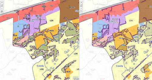
West City Sector
Review the existing sector plan and the proposed updates in side-by-side interactive maps.
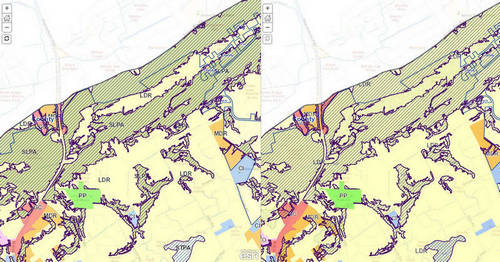
North City Sector
Review the existing sector plan and the proposed updates in side-by-side interactive maps.
An open house for city and county residents to learn more about the sector plan proposals has been scheduled:
Thursday, March 1
North & West City Sector Plan Update
City-County Building
Main Assembly Room
400 Main St.
5:00 p.m.
Note to County Residents:
Although these are termed City sectors, a portion of each sector is located in unincorporated Knox County and these updates will require consideration by both Knoxville City Council and Knox County Commission.
The proposed Hillside and Stream Protection updates will also be discussed as part of the City’s One Year Plan Update. Visit the project page to learn more about the process and for meeting times.
Proposals are scheduled to go before MPC Commissioners at their April 12th meeting. Their recommendation will be forwarded to City Council and County Commission for consideration in May.
For more information or to submit a comment about the plan update, contact Jeff Archer at (865) 215-3821 or jeff.archer@knoxmpc.org.
Related News